Low water levels on Mississippi threatens shipping
Daily News Article — Posted on December 3, 2012

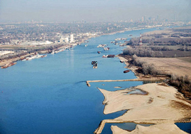
Man-made dikes that are normally under water can be seen Wednesday along the shoreline of the Mississippi River south of St. Louis. The dikes, which are perpendicular to the shore, help direct water back into the river to maintain a navigable depth. They have been exposed, along with their large sandbars, by months of drought and low water levels that could close the river to barge traffic.
(by Jim Salter and Jim Suhr, The Denver Post) ST. LOUIS – After months of drought, companies that ship grain and other goods down the Mississippi River are [greatly concerned about] a potential nightmare: If water levels fall too low, the nation’s main inland waterway could become impassable to barges just as the harvest heads to market.
Any closure of the river would upend the transport system that has carried American grain since before steamboats and Mark Twain. So shipping companies are scrambling to find alternative ways to move tons of corn, wheat and other crops to the Gulf Coast for shipment overseas.
“You can’t just wait until it shuts down and suddenly say, ‘There’s a problem,’ ” said Rick Calhoun, head of marine operations for Chicago-based Cargill Inc. “We’re always looking at Plan B.”
The mighty Mississippi is approaching the point where it may become too shallow for barges that carry food, fuel and other commodities. If the river is closed for a lengthy period, experts say, economic losses could climb into the billions of dollars.
“The longer it lasts, the worse it gets,” said Don Sweeney, associate director of the Center for Transportation Studies at the University of Missouri at St. Louis. “It’s inevitable that it will mean higher prices down the road.”
The focus of greatest concern is a 180-mile stretch of the river between the confluences of the Missouri River near St. Louis and the Ohio River at Cairo, Ill. That’s where lack of rain has squeezed the channel from its normal width of 1,000 feet or more to just a few hundred feet.
The river depth is 15 to 20 feet less than normal, now about 13 feet deep in many places. If it dips to around 9 feet, rock pinnacles at two locations make it difficult, if not impossible, for barges to pass. Hydrologists for the National Weather Service predict the Mississippi will reach the 9-foot mark by Dec. 9.
Associated Press. Reprinted here for educational purposes only. May not be reproduced on other websites without permission from The Denver Post. Visit the website at denverpost.com.
Questions
1. Define the following words relating to the article:
- commodities
- consumers
- confluences
- hydrologists
2. What types of commodities do barges move down the Mississippi river?
3. What would prevent barges from traveling down the Mississippi? Be specific.
4. How are shipping companies addressing the potential problem?
5. How will the low water levels affect consumers?
6. The Army Corps of Engineers is planning demolition work to deepen the shipping channel by blasting rock from the bottom of the river, but the project likely wouldn't begin until February or March. Shipping companies are asking the Corps to speed up its plan. How important do you think it is for the Army Corps of Engineers to do so? (Consider cost, ability to speed up the project, etc.) Explain your answer.
Background
U.S. Army Corps of Engineers:
The carriers say reduced water flow, coupled with the drought, will soon cause the Mississippi River to drop so far that exposed rock on the river bottom will stop commercial traffic. The companies want the U.S. Army Corps of Engineers to speed up its plan to blast rock from the bottom of the river near the southern Illinois towns of Thebes and Grand Tower, to deepen the shipping channel.
The Corps is planning the demolition work and it has sent out a call for bids, but the project likely wouldn't begin until February or March, he said. The Corps hasn't dynamited rocks in the river since the drought of 1988 and 1989, Corps navigation manager for the Mississippi Valley Steve Jones said.
While some carriers think river traffic could be severely affected by Dec. 10, Mr. Jones said that if the drought continued, he would expect major problems by around Christmas. (from wsj.com)
FINDING ALTERNATIVE WAYS TO MOVE THE GOODS:
- River shippers are bracing for the worst, weighing train and truck alternatives to move a staggering volume of cargo, if necessary.
- Seven million tons of farm products are shipped via barge in a typical December-January period, along with 3.8 million tons of coal, 1.7 million tons of chemical products, 1.3 million tons of petroleum products and 700,000 tons of crude oil.
- Trains already haul a vast volume of material, but switching from river to rail isn't that easy, especially on short notice. Cargill, for example, uses 1,300 of its own barges on inland waterways. Finding that much capacity elsewhere is no simple task.
- "We'll look for other sources of transportation to the extent we can. But if you take away this important artery, you can't just snap your fingers and replace it with trains," Rick Calhoun of Cargill said. "There aren't just trains sitting around. They're already pretty busy with their business on their books."
- Tractor-trailers can pick up some of the slack. But some cargo, such as coal, just isn't cost-effective to haul by truck over long distances, said Bob Costello, an economist with the American Trucking Associations. (from startribune.com)
